
Main Navigation Menu:
Bankhead Page Navigation Menu:
Bankhead/Sipsey Wilderness Hikes
 |
 |
 |
 |
Intro
The Bankhead National Forest is home to the scenic Sipsey Wilderness. The 30 miles of hiking trails here will give you a great opportunity to explore the whole area. Sipsey is home to scenic creeks, waterfalls, and canyons. This page will cover hikes to Fall Creek Falls, Caney Creek Falls, Kinlock Falls, Holmes Chapel Falls, Parker Falls, , Mize Mill Falls and Turkeyfoot Falls.
Trail Head
The trail head for the hike to Fall Creek Fall is located just off Co Rd 6/ Rd #6. The trail head for the Caney Creek trail
located on Co Rd 2.
To access the trail head (West Borden Creek): The trail head is about 1/2 mile from the parking area. So you
will have to walk a ways and there you will see a thing with maps and such. Just walk across the bridge and you will
see the trail on the other side of the bridge. It's the trail on the left.
To access the trail head (Caney Creek): If you are coming from Hwy 33, the trail head for Caney Creek
is about 3.5 or 4 miles down Co Rd 2. It's on the right side of the road. You will see a wooden sign.
To access the trail head (Turkeyfoot Falls): Go past the Sipsey Recreation/ Picnic Area. Cross over the bridge and park on the shoulder when you see the first
gravel road to your left. The small pathway will be located across the road from the gravel road.
Kinlock Falls: Kinlock Falls is located less than 100 yards from the parking area on Kinlock Road.
Parker Falls Trail Head: The parking area for Parker Falls is located on Kinlock Road. It's just before you reach the Kinlock Falls area. I will include
GPS Coordinates for the trail head location in the GPS Coordinates section.
Holmes Chapel Falls Trail Head:You can find the location of Holmes Chapel Falls in the GPS coordinates section to help you locate the starting point for Holmes Chapel Falls.
Wolfpen Falls: There is no trail to Wolfpen. It seems best to start at Wolfpen Cemetery.
Eagle Creek/Deer Skull Falls Start Point: The parking spot will be at Cranel Road and Forest Road 221. I have GPS coordinates listed for this spot
Shangri La Falls Start Point: The starting point to hike to Shangri La falls is Walston Ridge Road. I have a GPS coordinate listed below for that. However, you may want to start
a little further down the road than the coordinates that I have listed.
Coal Mine Branch Falls Start Point: The starting point to Coal Mine Branch Falls is on Holmes Chapel FS Road. I have a GPS coordinate listed below for that.
Difficulty
Fall Creek Fall:The trail is kind of long and has some ups and downs. You will have to navigate through a couple terraces
and the footing can be a touch slippery if it's muddy in those areas. Other than that it's a fairly safe trail.
It can be a little physically demanding just because it's out and back and you can get a little tired on the way
back.
Caney Creek Falls:This trail is pretty easy. However, the way back is mostly uphill.
Parker Falls: This trail is fairly easy until you get to the first small waterfall and have to hike your way down into the canyon. Just use caution
here.
Holmes Chapel Falls Trail Head:You can find the location of Holmes Chapel Falls in the GPS coordinates section to help you locate the starting point for Holmes Chapel Falls.
Wolfpen Falls: There is no trail to Wolfpen and you will have to hike down into the canyon and back up. It's not real far though. I have GPS coordinates listed below.
Eagle Creek/Deer Skull Falls: There is no trail to either waterfall. You should use a GPS to locate them. I have the GPS
Coordinates here on the page.
Shangri La Falls: There is no trail to the waterfall. Due to the area being so grown up you will want to do this one in the winter. You should GPS to locate it. I have the GPS coordinates listed below.
Coal Mine Branch Falls: There is no official trail to the waterfall. This area is grown up in some places so you will want to do this one in the winter. You will want to use GPS coordinates to locate. I will list the coordinates below.
Hiking the Trail
Fall Creek Fall: The deal with the west borden trail is it is actually not an "official" trail. It became a trail as other hikers used it to access
other areas and what not. This trail is also used to connect folks with the sipsey trail so they dont have to cross over the water.
When you start this trail you will start on the West side of Bordon Creek. The scenery is awesome. On one side you have the
creek and on the other you have high boulders. As you walk along you will end up taking a turn to the right and hit trail 209 (sipsey).
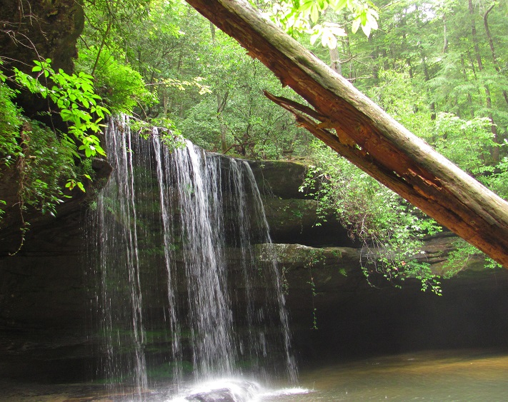
from here you will continue to follow sipsey (209) until you reach Fall creek. Fall Creek waterfall is probably the best waterfall in the Sipsey Wilderness according to several hikers.
The the hike to the falls is about 2.7 miles, so round trip we are talking 5.4 miles or so.
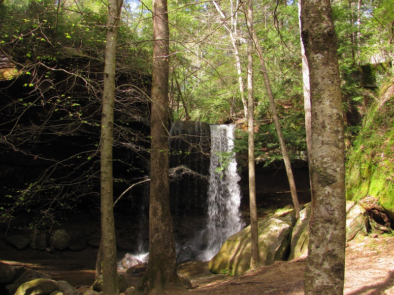
Caney Creek Falls: This trail is pretty easy, just follow it down to the waterfall. Along the way enjoy the view of the
Alabama woodlands. Once you get to the end you can just walk down to the bottom of the waterfall and enjoy the view of the falls and canyon.
Turkeyfoot Falls: When you locate the footpath (located less than a 1/2 mile from Sipsey Picnic Area just across the bridge..see trail head location above) just follow it towards the sound of a waterfall. You will come upon Mize Mill Fall first. Walk down the
embankment to view the falls. After visiting Mize Mills just continue on along the path. In about five minutes you should reach Turkeyfoot Fall. I did not go any further than this.
Kinlock Falls: Kinlock Falls is located less than 100 yards from the parking area on Kinlock Road.
Parker Falls: For the Parker Falls trail head you will see a path on the right side of the dirt parking area. Start your hike here. Although this is not an
official trail the path is well defined. Just follow it until you reach a small creek and small waterfall. From here you will continue down into the canyon to the base of the small waterfall.
This small waterfall empties into Parker Branch. When you reach this point turn to the right and follow the branch for about 0.1 miles until you reach Parker Falls. You may have to cross
the branch a few times so wear waterproof boots. It's pretty shallow in the places you will have to wade across so a good pair of boots will work fine. It's about one mile from the parking area to
Parker Falls, so about a two mile round trip.
Holmes Chapel Falls: This is an easy path to follow once you know where to start. It's a very short walk from your vehicle to the waterfall.
Sougahoagdee Falls: The path to Sougahoagdee Falls begins at the new bridge over Brushy Creek on Hickory Grove Road (I have the GPS coordinates listed on the GPS coordinates section).
Start your hike here and all you have to do is follow the path along side the creek. The hike out to the waterfall is about 1.9 miles one way. You shouldn't have any trouble finding
your way because most of your hike you will have high canyon walls on your left and Brushy Creek on your right. Just follow the path that other hikers have laid down along the creek.
At the end of the 1.9 miles you'll be rewarded with a scenic large waterfall. Just go back the way you came to complete the hike.
Wolfpen Falls: There is no trail to Wolfpen. You will have to bush whack your way into Wolfpen Canyon. The easiest and possibly quickest way to do this is to
start at Wolfpen Cemetery and hike your way down into the canyon. You will see the remnants of a trail at the cemetery and you can start hiking down from there. The trail eventually fades
away. Just follow a small branch that flows down into the canyon, eventually flowing into Wolfpen creek. Then just follow Wolfpen creek downstream until you reach the waterfall. I suggest
NOT hiking in these type of areas without a good map and GPS. I have included GPS coordinates of Wolfpen Cemetery and Wolfpen Falls for those who have a handheld unit.
Eagle Creek/Deer Skull Falls: Note:There is no trail to either of these waterfalls, use a GPS. I have the Coordinates
listed here on the page. I started my hike from the GPS starting point I have listed here. I hiked my way down to the bottom of the hollows using the guidance of my GPS. After hiking
downhill and reaching the bottom of the hollow I arrived at a small creek. From here you can follow the creek downstream. It will eventually lead you to a larger creek. Follow the larger creek downstream a
short distance and you will arrive at Eagle Creek Falls. Be careful making your way below the falls. If you want to continue on to Deer Skull falls it will be about another
0.5 miles further. Just follow the creek downstream. You will make a left turn at another creek. Hike upstream until you reach Deer Skull Falls.
Shangri La Falls: This is another hike with no trail. You will want to use a GPS. I have the coordinates to Shangri La Falls listed below. The starting point is Walston Ridge Road, where their is a kiosk for the North
Alabama Birding Trail. I started here, but I think you would be better to drive a little further down the road. I saw some others parked along the side of the road on my way back to the truck. Following the gps signal just hike your way into the woods
from Walston Ridge Road and make your way down into the hollow. Eventually you will end up at Collier Creek. Just keep following your gps. You may have to criss cross the creek a few times as the hollow's
walls can get steep on either side. You may have to enter into the hollow a little bit to the north of the waterfall due to the steepness of the bluffs close to the falls. It's less steep to the north. Again, this is one of those
hikes with no trails so that makes it more difficult to navigate. You'll just have to do like I did and use your best judgement on how to hike your way to it.
Coal Mine Branch Falls: The hike to the waterfall from the starting point is relatively short. From where you park you will walk down a trail that will lead you
to an open field. Once you reach the open field turn left and hike along the outer rim of the open field. You may be able to see where others have trampled down the trail and follow that path. Just
before you get to the end of the open field you will turn left back into the woods. You will be able to hear the creek. Just find the best way to hike down into hollow. Once you've
reached the creek just follow it down stream for a short distance and you will be at the top of the waterfall. There is a way to the bottom, but it is steep and you will want to use
caution if you choose to hike to the bottom.
GPS Coordinates
Caney Creek trail head:
N 34°14.111' W 087°26.040'
Caney Creek Falls:
N 34°14.748' W 087°25.979'
Turkeyfoot and Mize Mill Falls Path (path begins on side of the road)
N 34°16.939' W 087°24.408'
Mize Mill Falls:
N 34°16.998' W 087°24.403'
Turkeyfoot Falls:
N 34°17.093' W 087°24.338'
Kinlock Falls:
N 34°18.514' W 087°30.157'
Parker Falls trail head parking:
N 34°18.174' W 087°29.726'
Parker Falls:
N 34°18.231' W 087°29.054'
Holmes Chapel Falls parking:
N 34°16.600' W 087°15.409'
Holmes Chapel Falls:
N 34°16.511' W 087°15.439'
Sougahoagdee Falls Parking:
N 34°15.085' W 087°14.772'
Sougahoagdee Falls:
N 34°15.238' W 087°16.868'
Wolfpen Cemetery: (starting point to Wolfpen Falls)
N 34°17.011' W 087°25.707'
Wolfpen Falls:
N 34°17.398 W 087°25.723'
Eagle Creek and Deer Skull Falls starting point
N 34°16.890' W 087°26.682'
Eagle Creek Falls:
N 34°17.343' W 087°26.723'
Deer Skull Falls:
N 34°17.826' W 087°26.613'
Shangri La Falls Parking:
N 34°17.410' W 087°18.491'
Shangri La Falls:
N 34°16.752' W 087°18.385'
Coal Mine Branch Falls Parking:
N 34°16.615' W 087°16.973'
Coal Mine Branch Falls
N 34°16.336' W 087°16.845;
Scenery
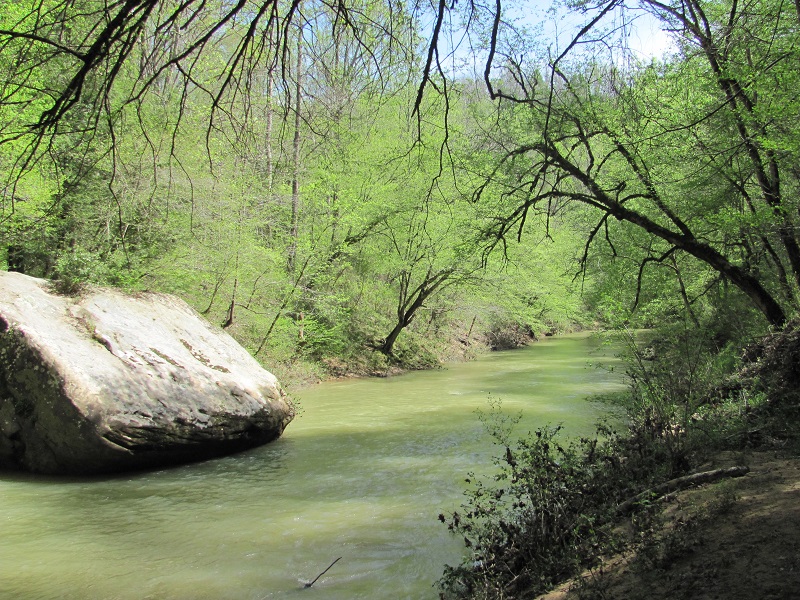
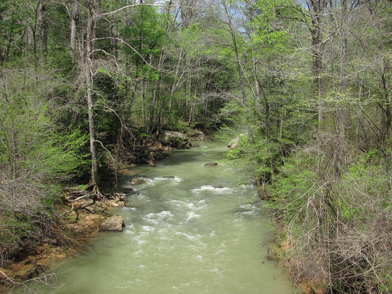
The Bankhead National Forest has multiple locations with scenic creeks, canyons, and many waterfalls. The scenic Sipsey River flows through the Sipsey Wilderness area as well.
Trail Maintenance
Fall Creek Fall: The West Borden trail is not really maintained, but in decent shape. You will have to cross over some downed trees some times, but its not too bad.
The Sipsey Trail is well maintained since it is actually an official trail.
Caney Creek Fall: The trail is pretty clear and easy to hike.
Facilities
The facilities depend on which trail you use at Bankhead. The Sipsey Recreation Area, Brushy Lake Recreation Area, and Pine Torch trail head all have a restroom area. The other areas listed here do not.